Enhancing Wildland Firefighter Safety

Enhancing Safety for Wildland Firefighters and Other Emergency Personnel

In the fight against forest fires, clear and reliable asset and personnel tracking is mission critical. Advanced Situational Awareness, LLC, chose our 50-Watt UHF Mobile Amplifier as part of their RangerTrax© solution to ensure consistent RF tracking in areas where cell service is non-existent, weak, or otherwise down due to damage.

During life-threatening situations, RangerTrax’s radio-based GPS system, provides essential real-time asset and personnel tracking and mapping over RF. This capability enhances the situational awareness and safety of wildland firefighters, allowing them to navigate and coordinate effectively under extreme conditions. Using our rugged mobile 50 Watt UHF amplifier ensures that RangerTrax operates independent of satellite and cellular networks, providing a dependable solution that empowers firefighters to focus on saving lives and protecting communities.

Asset and Personnel GPS Tracking over RF and LTE

Map Graphic

RangerTrax© from AdvancedSA tracks personnel location and equipment assets in Radio and or Cellular (LTE) range. RangerTrax© Enhances Wildland Firefighter Safety and SAR efforts improving Situational Awareness with NWCG standard PIN Drops and Man-Down Alerts. Knowing an asset’s coordinates increases the ability to aid personnel in the event of an IWI.

ASA’s GPS tracking over Radio Frequency has a range typical of Land Mobile Radios and Nationwide LTE networks using dual SIM, connectivity with MCPTX capability for First Responders!

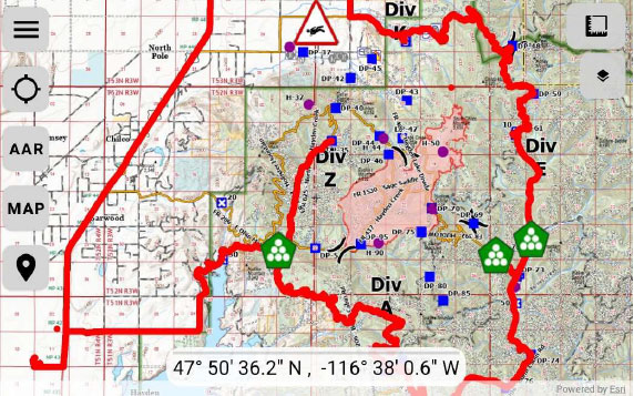
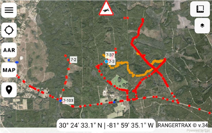
RangerTrax©, Powered by ESRI, provides user access to private ArcGIS organizations or public servers to pre-load offline, Aerial and Topo map types in separate layers. Supports custom and unique call signs for each asset. Repeat mode of operation extends the operating range where needed. With connectivity, RangerTrax© automatically uploads RF track data at near Real Time intervals to ASA’s Web Portal Server or any Enterprise Geospatial Portal providing a Common Operating Picture from the field.
Drone
Image: A Tethered UAV also serves as a portable communications repeater antenna mast extending RF and LTE coverage while supporting payloads such as EO&IR cameras.

RangerTrax©, Asset & Personnel GPS Tracking Radios with MCPTX

  • ASSET & PERSONNEL GPS TRACKING: over RF and LTE With MCPTX
  • Radio Agnostic p25 LMR to LTE, Share DATA & Location
  • Dual SIM Tablets & Cell Phones With First Responder Priority
  • RANGERTRAX© Runs on Android, no Login, Auto Start
  • MAN-DOWN ALERTS: GPS Location With Call Sign & Breadcrumbs
  • CUSTOM CALL SIGNS: With Unique User IDs
  • PIN DROPS: NWCG Symbols Broadcast to all Users
  • LAST KNOWN LOCATION: After Signal Loss Call Sign Flashes a red X
  • GPS COORDINATE DATUM SELECTIONS: DDM, DMS, DD,
  • MEASURE: Area, Perimeter & Linear Distance
  • AFTER ACTION REVIEW: Date and Time Stamped GPX File for Playback
  • POWERED BY ESRI: ArcGIS Runtime SDK, ArcGIS Maps:
  • Pre-loaded Aerial and Topo Layers With QR Code Reader
  • ArcGIS Organization map Access Compatible
  • UAV OPTION: Tethered Comms Repeater & Free Flight
  • KNOX SECURITY: Mobile Device Management, Runs in Kiosk Mode
  • MIL STD 810H / IP68: Compliant for Shock, Vibration / Dust, Water

For more information about our full range of land mobile radio amplifiers, click here.

For more information about RangerTrax©, click here.

Scroll to Top